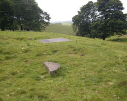
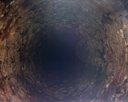
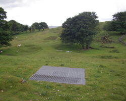
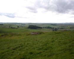
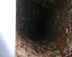
Jowle Grove Mine which is above Peak Forest, south east of Eldon Hill, lies along the east-west trending White Rake or Watts Grove Rake (Watts Grove mine is also nearby). This area has many small and medium-sized veins with hillocks and opencuts, together with natural dolines (surface collapses above cave passages) along the veins. A metal grill has been fitted to the large engine shaft in the place of old wooden sleepers and ginging can be seen through this. It is well constructed and ginged to a depth of perhaps 30m (100 feet), and it is a fine example of the skills of the Old Man. Alongside there are remains of a crushing circle with a broken gritstone crushing wheel.
There is a crushing circle and part of the wheel, a ruined coe, a small possible part of a gin circle and a grilled engine shaft at otherwise disturbed ground within the belland yard at Jowle Grove. The working of Jowle Grove is documented from at least 1789. Mining had ceased by the late 19th century when the Ordnance Survey Map of 1880 describes the rake as old.
Nearby is Watts Grove mine.
Watts Grove rake lead mines are listed as a Scheduled Monument.
The remains of Watt’s Grove Rake lead mines 520m north of Sweetknoll are particularly well preserved and include a diverse range of components relating to the mining of this vein. Rake workings of such veins are now rare, and this example is one of the best preserved examples in the Peak District. The standing, earthwork, buried and rock cut remains provide evidence for both the historical and technological development of what was once a far more extensive, multi-period mining landscape. They incorporate a wide range of mining and processing features, which enable the development of the mine working and its chronological range to be reconstructed. The large rake, shafts, hillocks and other extraction features provide evidence for methods of extraction whilst other processing areas will contain deposits showing the effectiveness of these techniques. The mining remains also provide an insight into the Derbyshire Barmote Court system of mining and the constraints this imposed on the miners of the area.
The monument includes the earthwork, buried, standing and rock cut remains of Watt’s Grove Rake. The monument is linear in shape and runs east to west for approximately 1.45km along the south side of Eldon Hill, on the western slopes of Conies Dale. The continuous line of workings along the vein includes intermediate concentrations of areas of activity associated with Watt’s Grove and Jowle, or Joule Grove mines. Linear rake mining of lead was typical in the Peak District.
It is unknown when the rake was first worked, but Dirtlow Rake, from which Watt’s Grove Rake branches, is thought to have been worked in the medieval period. The working of Jowle Grove is documented from at least 1789 when it was recorded that Samuel Fox `can drive a level from Jowl Grove to Portaway Mine, seven feet and two feet in size and have all the ore got in driving the said level’. Mining had ceased by the late 19th century when the Ordnance Survey Map of 1880 describes the rake as `old’. Watt’s Plantation, which follows the line of the rake, was planted between 1880 and 1922.
The mines would have been worked under the jurisdiction of the Barmote Courts, the legal administrative unit governing Derbyshire lead mining. The Derbyshire system of mining was largely based on local mining customs and consisted of individual groups of miners or small mining companies working relatively short lengths of the vein.
The monument survives as a series of earthwork, buried and standing remains which include belland yard walls (substantial walls built around dressing floors in order to prevent cattle straying and eating grass contaminated by lead), ruined coes (stone built shelters or sheds), open cuts (veins worked open to daylight), a bouse team (a bin into which ore was stored before processing), water channels, washing floors, leats, buddling dam (an earth dam into which was placed the dirt and sludge resulting from the process of separating small sized ore from adhering dirt (buddling)), crushing floor (an area where ore was crushed ready for further treatment), gin circles (remains of horse powered winding apparatus), climbing shafts, water storage pond and engine shaft.
The remains of Jowle Grove mine are located at the eastern end of the monument, in Watt’s Plantation, where a group of features mark a concentrated area of activity. Included within this area is a crushing floor paved with limestone slabs which is, unusually, protected by a low retaining wall. The wall may have acted as a very small belland yard wall. The well preserved remains of an engine shaft and gin circle are also visible although the shaft is now covered with timber baulks. A stone built double coe, now filled with limestone rubble, is thought to house a climbing shaft which provided access to the working places in the mine.
Another concentrated area of activity lies immediately to the west of Jowle Grove but still within Watt’s Plantation. This is known as Watt’s Grove Mine. The remains of a gin circle and a funnel shaped water storage pond are easily visible. The gin circle has partly collapsed into an open cut but is still clearly discernable on the ground. Part of a small area, in the southern section of the plantation, has been disturbed but the remains of a shaft and the hillocks survive and form an important element in the otherwise undisturbed linearity of the rake.
The rake continues in a westerly direction and is marked by up to three parallel lines of large hillocks made up of limestone deads (waste rock which contain no ore or insufficient quantities to warrant extraction). An area of the rake, centred at national grid reference SK11808065 is enclosed by a belland yard wall which contains the remains of dressing floors, a buddle dam, washing ponds, leats, a water storage pond, a climbing shaft and a main shaft although the latter is now covered in concrete. The water storage pond is known to be at least five feet deep. Also within the enclosed section two of the open cuts contain walls of deads which are built up between the vein walls on bunnings (stagings built across a worked out vein onto which the deads were placed). The dry stone walls provided a convenient way to store waste rock which saved the trouble and expense involved in drawing it to the surface. To the west of the belland yard wall the rake continues a further 760m and ranges in width from 60m to 20m. This section of the rake lies within a plantation and is defined along most of its length by field boundary walls. Along this section there are a lot of examples of individual shafts joined together by well preserved hillocks. These remains demonstrate the vertical working of the rake by mines with access to several meers of the vein at a time (a meer is a linear measurement equivalent to 32 yards). The extraction techniques demonstrated by these existing surface remains illustrate the way that the legal framework governed the working of the lead mines in Derbyshire.

