HOPE
Hope means ” an enclosed valley”. The village sits at the junction of the River Noe, coming from the Vale of Edale and Peakshole Water from Castleton. The Noe runs between two dominant high points; the 1563 foot “Lose Hill” to the west and the 1523 foot “Win Hill” to the east. Their names supposedly represent the fates of the two opposing armies of King Edwin of Northumbria and King Penda of Mercia, who confronted each other from these vantagepoints in the 7th century.
Hope is on the site of a battle won by King Athelstan in AD 926. In 1086, the Domesday Survey records Hope as a royal estate, which along with Ashford and Bakewell, paid a tribute of “five cartloads of lead comprising fifty slabs”. At the time of the Domesday, what is now the Hope parish was part of the King’s Forest of the High Peak. In the church there are 13th century memorials bearing the symbols of forest officers or woodroffes, a term that survived as the name of a prominent local family for another 500 years and is still perpetuated in a local inn, the Woodroffe Arms. Both the popular Cheshire Cheese Inn, on the Edale road, and the Hope Post Office, formerly an inn, are over 400 years old.
Settlement goes back much further than the 13th century. The present church lies close to the place where the Roman road to Glossop climbed from the shallow ford of Peakshole Water and is only a few hundred yards from Navio, the most important Roman site in the Peak District. The laying of a pipeline across a field, south of the church, in 1955, uncovered a fifteen feet wide section of Roman road, paved with flat, rounded stones. The discovery pinpointed the approach of the Roman road, now known as Doctor Gate, to the Roman fort of Navio.
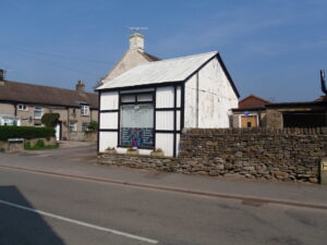
This is probably the last surviving building from Birchinlee (Tin Town) village which was built for the workers and their families when Derwent and Howden reservoirs were constructed.
At St Peter’s Church can be seen numerous gargoyles, an anglo saxon cross, Eccles cross and a guidestoop.


